Putting 10,000 School Campuses on the Map
Stanford Prevention Research Center
GreenInfo team: Amanda Kochanek, Andrew Nham, Gregor Allensworth, Jayita Bhojwani, Joseph Stout, Maria Lamadrid, Tim Sinnott
Project years: 2012 – Present
Overview
What challenges is this project trying to solve?
- Many public health policies restrict activities within a certain distance from schools. This is especially true for commercial tobacco marketing and sales.
- Distance calculations have traditionally used a single point based on a school’s address.
- Those are not very accurate, since school campuses can be large, and address points are sometimes placed in the wrong location.
What were the client’s objectives?
- Inspired by our work mapping parks and open spaces in California, Stanford researchers wanted to create a similarly accurate database of California’s roughly 10,000 school campuses.
- They also wanted to release the data for unrestricted use, so it could improve research and policy making done by anyone in California.
Results
- In 2016, GreenInfo released the first statewide, parcel-aligned school campus database for California.
- GreenInfo and Stanford used the data to create the Community Tobacco Assessment Tool, a web application used by county-level public health staff.
- The data have been improved and used for various purposes well beyond the original tobacco focus, including an assessment of tree canopy by Green Schoolyards America.
The Work
Concept Development and Database Design
The California School Campus Database was inspired by our work on the California Protected Areas Database, but we couldn’t simply apply the exact same approach to schools that we have used for parks.
- Unlike parks, California already maintains a comprehensive list of schools across the state. This provides a strong foundation, though the data is only at the address point level, and the points are often in the wrong place due to inaccuracies in converting addresses to coordinates.
- A single campus can house multiple schools. This is very common, with several named schools sharing the same campus footprint.
We needed to create an accurate school campus boundary layer. And we also wanted to maintain the ability to connect each named school back to the State of California’s ID code, since there’s a large ecosystem of educational data tied to those codes.
We achieved both by creating several layers of data, depending on need. These are described in more detail at californiaschoolcampusdatabase.org.
Data Review
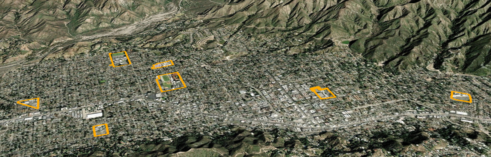
Using school addresses from the State of California plus parcel boundary data from each county, we created an initial rough draft of the school campus database.
Then our team reviewed every campus boundary for accuracy, comparing them to satellite imagery and other online sources to ensure the boundaries of more than 10,000 campuses were as accurate as possible.
New uses and ongoing improvements
We created a stand-alone website to host the data, californiaschoolcampusdatabase.org, and published an updated version in 2021. Unlike our work on California parks and open spaces, our school campus mapping does not have ongoing funding.
However, through ongoing collaborations with Stanford, Green Schoolyards America, and other clients, we have been able to put the data to use.
For Stanford, we created the California Tobacco Health Assessment Tool (cthat.org). CTHAT is used by public health professionals across the state to better understand the demographics of the areas where they work.
We also helped Green Schoolyards America conduct a California Schoolyard Tree Canopy Study, which is part of their effort to establish a California Schoolyard Forest System.