Conserving 30% of California by 2030
California Natural Resources Agency
GreenInfo team: Amanda Kochanek, Andrew Nham, Conserving 30% of California by 2030, Dariya Draganova, Kristina Yamamoto, Maria Lamadrid, Tom Allnutt
Project years: 2022-present
Overview
What challenges is this project trying to solve?
- California set an ambitious goal to conserve 30% of its land and waters by 2030. We needed a way to track how much is conserved now, and then to update that regularly to track progress.
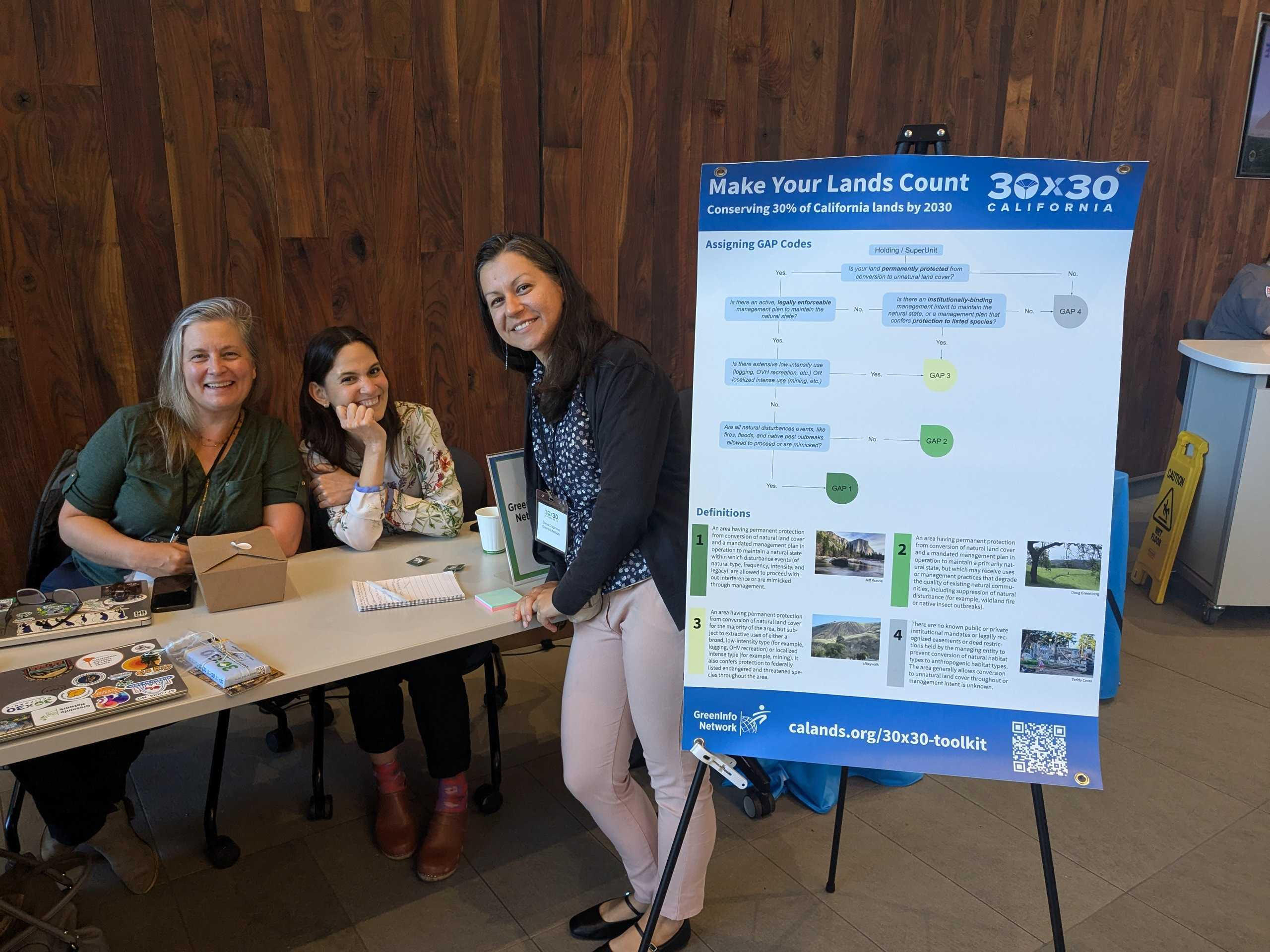
- Not all public lands count as conserved. To define what is conserved for 30x30, the state uses a national data standard called GAP codes. These were not well represented in existing public lands data, so we needed new ways to incorporate GAP codes into public lands data.
What were the client’s objectives?
- Develop new methods for incorporating GAP codes into public lands data
- Share those methods and encourage data updates with GAP codes.
- Publish regular updates to show progress toward 30x30
Results
- Public lands and easements datasets now include much more comprehensive and accurate GAP codes for most lands.
- Semiannual updates of GAP status have provided California with the data it needs to show progress toward 30x30.
- Improved documentation and methods provide a solid foundation for the program through 2030.
The Work
Starting with Existing Data and Standards
GreenInfo Network has long maintained the definitive databases of conservation lands in California — the California Protected Areas Database (CPAD) and the California Conservation Easements Database (CCED). In 2020, when Governor Gavin Newsom announced an executive order to conserve 30% of California’s land and waters by 2030, it was clear that CPAD and CCED would play a central role.
However, not all lands in CPAD qualify for 30×30. City parks with soccer fields, for example, provide important recreational amenities, but they aren’t meant to protect biodiversity. And some large expanses of federal lands allow significant resource extraction, so those also shouldn’t count in a program that aims to protect biodiversity.
To classify lands for conservation under 30×30, the California Natural Resources Agency adopted an existing data standard, called GAP, which defines levels of conservation based on the type of binding management plan a park has. At a high level, lands qualify for 30×30 when they have management plans that maintain at least 95% native land cover and prioritize biodiversity.
Adding GAP to CPAD and CCED
Our first task on this project was to find a way to incorporate GAP codes into our existing protected lands databases, CPAD and CCED. This might sound simple, but it’s not. That’s because a single park can contain areas with varying levels of protection. Think of a large campground with parking or a logged clearcut area compared with a restricted zone around a mountain river where only hikers are allowed.
Across the state, there are more than 15,000 parks managed by around 2,000 agencies, so we needed methods that would be accurate enough, but also easy to implement across all those lands.
Ultimately, we decided to focus on numerical accuracy over spatial detail. CPAD and CCED report the percentages of any lands that qualify for 30×30, without requiring data contributors to specify where exactly every acre of 30×30 land might be inside a park boundary. The state gets what it needs — an accurate count of 30×30 acreage — and agencies also get what they need — a method to report that’s accurate without being overly burdensome.
Outreach and Tools for Data Contributors
Since 2022, we have developed outreach materials, held webinars, attended conferences, and created a 30×30 toolkit system to support data contributors. Our goal with all this work is to meet people where they are: Large agencies with big mapping teams have different needs than small land trusts with just a few staff. Our materials and toolkits allow people to contribute GIS files, Excel spreadsheets, or even marked up PDFs.
In addition to receiving submissions from any entity that owns or manages conservation land in California, we also conduct direct outreach to key agencies we believe might have lands that might qualify for 30×30 but are not yet properly classified.
Updating 30×30 Progress
We incorporate the data contributions we receive, conduct careful quality review, and then produce release versions or the data that go to the California Natural Resources Agency for inclusion in their annual report of progress on 30×30.