About
Mission & Overview
GreenInfo Network works with clients whose missions focus on environment, public health, education, and social justice. We create maps, data, and web applications that empower our clients and their communities.
Since 1996, GreenInfo has collaborated with more than 1,000 organizations and agencies across the country and even internationally. We deliver user research, data analysis, and thoughtful design.
Our Story
GreenInfo Network emerged in the mid 1990s to map regional open space. We combined information from many organizations to create shared data everyone could use. From the beginning, our purpose was not just to help nonprofits and agencies use maps, but also to connect people and groups together. That ensures our work has collective value.
Some of what we do:
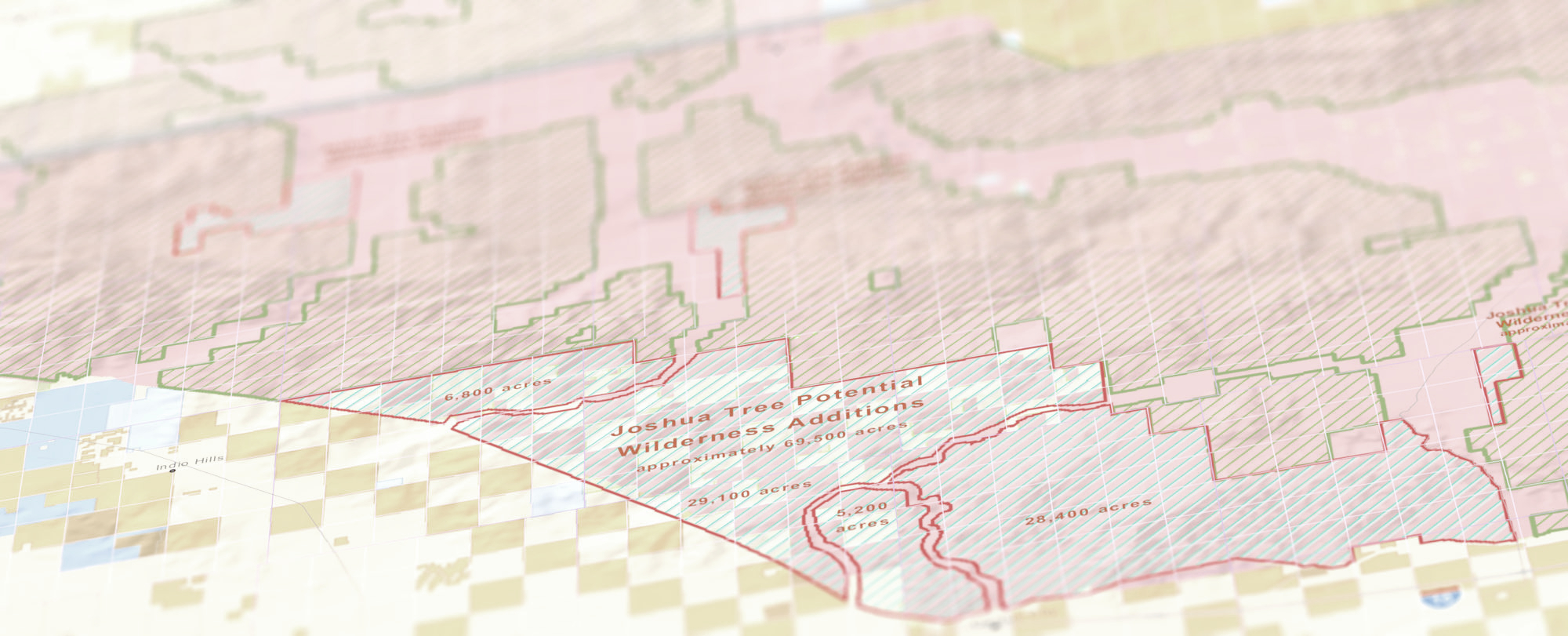
- Work with local, regional and state agencies to collect data about public lands.
- Map school campuses for public health researchers studying tobacco marketing.
- Collaborate with tribes and other partners to make maps of proposed national monuments.
- Design web applications to help transportation agencies plan for sea level rise.
- Assist state officials in equitably distributing millions of dollars in park funds.

Our team
We are data analysts, cartographers, designers, developers, and project managers. We develop data-driven maps, analyses, and reporting tools for a wide range of clients.
Team members collaborate across disciplines to help clients understand what they need to achieve their goals. Then we use the best available technologies to deliver beautiful, reliable, and easy-to-use data, analyses, maps, and tools.
GreenInfo is based in Oakland, California, with remote team members spread across the United States.
Amanda Kochanek
Spatial Data Automation Manager, Senior Project Manager

Andrew Nham
Data Felow / Geospatial Analyst
Anne Katzenberg
Financial Manager

Dariya Draganova
Geospatial Analyst and Developer

Gregor Allensworth
Sr. Web GIS Developer
Joseph Stout
Geospatial Analyst

Kristina Yamamoto
GIS Manager and Senior Analyst

Larry Orman
Emeritus Executive Director
Maegan Leslie Torres
Senior Geospatial Analyst, Cartographer

Maria Lamadrid
Design Researcher and UX Designer

Matt Lamborn
Executive Director

Robel Mengistu
Interactive Project Manager
Stephanie Ding
Senior Geospatial Analyst, Cartographer

Stephen Smith
Interactive Team Manager

Tim Sinnott
Senior Interactive Designer

Tom Allnutt
Web GIS Developer
Our board
The GreenInfo Network board provides strategic vision and management oversight. With a wide range of experience and connections, they are a critical part of our overall team.

Jaymee Go
Karin Tuxen-Bettman
Louis Jaffe

Michal Migurski

Mike McLaughlin

Travis White

Vyki Englert
Join our team
We commit to building an internal culture that is welcoming for people of all demographics and abilities. We are flexible to changes in life circumstances. We are people who care and who want to make a difference.
- No openings at this time.
Internship program
Our internship program provides students with key benchmarks to point to in their future career endeavors. Each intern produces a concrete product to start or enhance their GIS portfolio. We offer this paid program to students, and particularly encourage students who identify as BIPOC to apply. GreenInfo devotes funds, staff time, and mentorship to the program. We are also grateful to the donors that made this program possible.
- No openings at this time.
Our supporters
As a 501(c)3 nonprofit organization, our mission is fulfilled by helping other nonprofit and public agency clients meet their missions. While we are primarily supported through the work we do for our client organizations and agencies, we have received donations and some general and in-kind support, which we greatly appreciate. All donations to GreenInfo Network are tax-deductible to the extent allowed by law.
GreenInfo is a 501c3 nonprofit. Our tax ID number is 94-3313222. As a consulting organization, GreenInfo works mostly on a fee for service basis. We have a California contract, California CMAS: 3-21-70-2035C (Information technology goods and services – use this page to search for GreenInfo Network.
Special thanks
The Resources Legacy Fund has been a longstanding partner with GreenInfo Network, enabling us to support a wide range of environmental and conservation causes.
GreenInfo has been supported since its founding by the Esri Conservation Program. Esri develops a wide range of geographic information systems solutions and publishes ArcGIS software, which is made available to GreenInfo and many other non-profits through a granting program.
We gratefully acknowledge our founding donor, the Surdna Foundation, whose early investment when we started has been multiplied many times over; the Hewlett Foundation, who also provided startup support as well as support during our 2016 Executive Director transition; and a major past supporter, The David and Lucile Packard Foundation.
Image credits
What We Do page images
“Code Camping” by “Breyten Ernsting” is licensed under CC BY 2.0
“User Research Training” by “gdsteam” is licensed under CC BY 2.0
All other photos throughout the website were taken by GreenInfo staff.
Home page images
“North Fork American Wild and Scenic River, California” by “Bureau of Land Management” is licensed under CC BY 2.0
“Election Day 2022” by “Phil Roeder” is licensed under CC BY 2.0
“Cosumnes Recreational River, California” by “Bureau of Land Management” is licensed under CC BY 2.0