See This Project | All Projects for Client
We explored three solutions for park access:
- Building new neighborhood parks: Improving equitable access to nature for everyone, especially people who have been historically underserved, requires investments to build new parks and green spaces in neighborhoods without parks.
- Improving infrastructure and programming: Amenities like parking, restrooms, trash cans, recreational equipment, fields, playgrounds, trails and multi-language signage foster public spaces that are welcoming, safe and worth coming to.
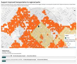
- Increasing public transit connectivity: In the six states examined, the report found that a significant number of people in neighborhoods without parks have limited access to personal vehicles, making regional parks or open spaces hard to reach.
The project was a collaboration of GreenInfo and the Institute of the Environment and Sustainability at UCLA, with support from The Wilderness Society and Resources Legacy Fund.
Project Development Process
Our work on ParkAccess.org unfolded over more than a year and included a few distinct phases.
First, we developed methods to turn a large amount of data about parks, people, and roads into insights about where people can or cannot reach parks near them. We built our analysis on open data sources using open source technologies, and we automated the process as much as possible so we could easily run the analysis on additional states.
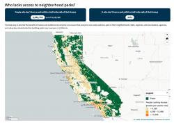
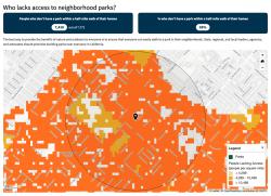
We used the Protected Areas Database of the United States to locate public parks and open spaces, and then we used data from the U.S. Census and Meta's Data for Good program to map the people who can or cannot access those public lands. You can read much more about the technical approach on ParkAccess.org’s About page.
Second, we built an initial version of the website with a few policy recommendations focused on regional park access. We then tested this initial version with park advocates and agency officials in several states in our analysis. Sharing our work with end users is a core part of our process, and in this case we discovered that our initial data presentation missed the mark in a number of important ways. Using input gleaned from two rounds of interviews, we first discovered where our initial website fell short, and then validated a redesigned version of the application to make sure our next version delivered what users need.
Finally, we rebuilt the site based on our revised, tested design and developed a final report summarizing the breadth of the work from start to finish.
Technical Approach
This project drew on a wide breadth of skills from user research and design to analysis, scripting, processing and web development.
We built pipelines for processing data from the U.S. Census, Meta’s Humanitarian Data Exchange, the Protected Areas Database of the United States, and OpenStreetMap. To process and store data, we used Postgres, Python, and a routing engine called Valhalla, as described in much more detail in the ParkAccess.org Methodology page. All our work was done with an eye to repeatability, since we needed a method that scaled from one state to six, and more in the future.
The final website at ParkAccess.org is built on the Django application framework, with Leaflet and Mapserver for data presentation.
Focus: Environment, Public Health, Recreation
Services: Interactive Solutions, GIS Services, Analysis, Data, Applications Development, Web Mapping, Website Design, Design Research
Project Years: 2023-2024